The UK Government’s Policy for a GDF requires the GDF developer, Nuclear Waste Services (NWS), to find two things – a suitable site and a willing community.
A GDF cannot go forward without both being in place.
At this stage in the Programme, there are three Community Partnerships/Search Areas:
Search Areas are the geographical areas on land within which NWS considers potential sites for a GDF. They are defined by electoral ward boundaries.
The Theddlethorpe Search Area covers the electoral wards of Withern and Theddlethorpe and Mablethorpe.
This Search Area was identified by the Theddlethorpe GDF Working Group who looked at available information on local geology, environmental issues, transport infrastructure and safety –
You can read more about this in the Evaluation Reports below.
It is important to note the boundaries of Search Areas are not fixed and as NWS’ investigations progress, the Community Partnership may review and refine the Search Area, as it identifies areas that may be ruled out or brings in additional areas that were not initially part of the Search Area.
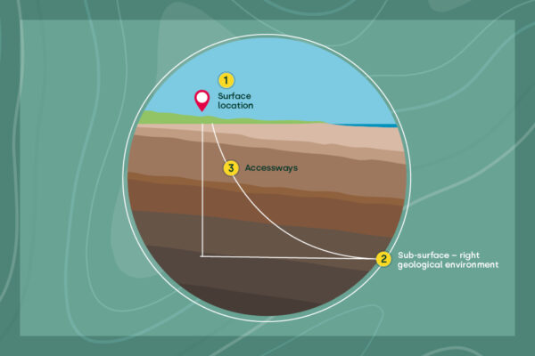
A GDF will comprise three main elements – the right Sub-surface (underground) geological environment for the disposal area, a Surface location, and the ability to connect the two with Accessways (tunnels).
It is difficult to carry out some of the more detailed feasibility studies required in a large Search Area, and in the inshore area off the coast .
NWS has identified a smaller ‘Areas of Focus’ in the Search Area, as the next step in finding a potentially suitable site, as this video explains Finding Our GDF Site.
This allows focussed site evaluation studies and use of resources to consider the potential for an area to safely host a GDF.
NWS has applied its methodology for identifying Areas of Focus to define the Sub-surface, Surface and Accessway Areas of Focus in the Search Areas.
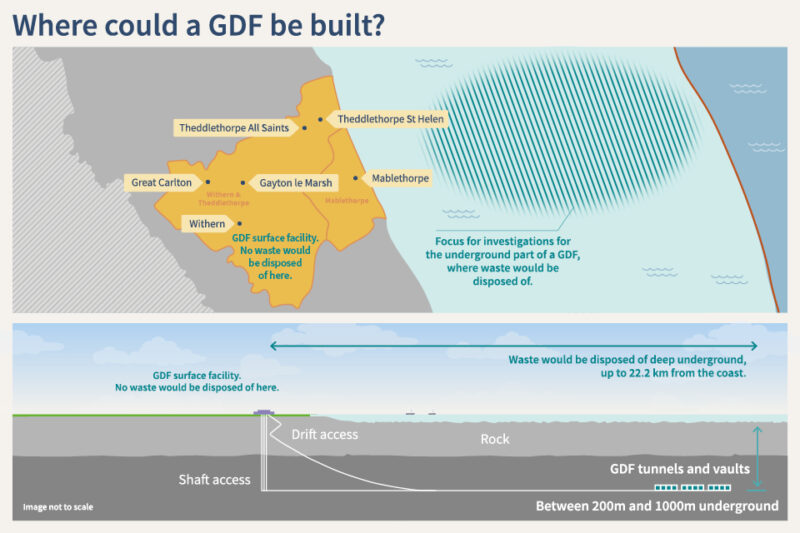
A Surface Area of Focus north of the A157, between the villages of Gayton le Marsh and Great Carlton, has been identified which NWS will prioritise and consider further.
You can read about Areas of Focus in the brochure Identifying Areas of Focus in the Theddlethorpe Search Area
You can find more information about the GDF Programme in the Theddlethorpe Search Area by visiting the NWS website.
Deep geology up to 22km beyond the coast (known as the ‘inshore area’) is being considered for the siting of the subsurface (underground) elements of a GDF and the Working Group agreed that research should begin in this area.
Nuclear Waste Services (NWS) are carrying out ongoing work and have undertaken a large data gathering activity to develop an understanding of the subsurface.
Find out more about this work on our page Exploring the geology of the area.
A surface facility on land within the Search Area would provide access to a disposal area deep in the rock beyond the coast.
There are six siting factors and 26 associated ‘evaluation considerations against which NWS will assess site suitability throughout the siting process.
This video explains the six siting factors – more information
Theddlethorpe is covered by Eastern England Subregion 2 in the National Geological Screening for a GDF study.